Editor's note: This story was updated Monday 8 a.m. EST.
A storm currently impacting western Cuba and the Yucatan peninsula has continued to grow and gather strength the past few days and has since been forecast to make landfall in North Florida later this week as a major hurricane. Over half of Florida’s counties are now under a state of emergency.
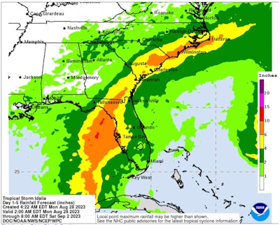
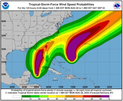
The National Hurricane Center reported at 8 a.m. EST Monday that Tropical Storm Idalia is expected to become a hurricane later today. Maximum sustained wind speeds are currently 65 mph. At 74 mph Idalia will become a Cateogry 1 hurricane and is forecast to become a Category 3 storm with max winds of least 111 mph before making landfall near Cedar Key early Wednesday morning about 90 miles north of Tampa. From there it's expected to travel northeast near Jacksonville into Georgia and the Carolinas.
“Idalia is now forecast to become a major hurricane before it reaches the Gulf coast of Florida,” NHC stated in its 8 a.m. update. “The risk continues to increase for life-threatening storm surge and dangerous hurricane-force winds along portions of the west coast of Florida and the Florida Panhandle beginning as early as late Tuesday.”
[Related: Flooding brings on EV fires]
A hurricane watch has been issued along the Gulf Coast from Mexico Beach in the Panhandle to Fort Meyers roughly 100 miles south of Tampa. Mexico Beach was devastated by Category 5 Hurricane Michael in 2018.
According to Gas Buddy's top analyst Patrick De Haan fuel availability could become an issue.
"We're initiating the steps to activate our tracker given the upgraded intensity forecasts. With the flow of gasoline likely partially impacted by Marathon's Garyville refinery fire late last week and now partial shutdown, plus a minor fuel contamination issue at CITGO's Tampa fuel rack where it dispatches fuel deliveries, I've become a bit more concerned with fuel availability for Florida with more evacuations likely to happen in the days ahead," De Haan said.
A forecast from Sunday morning showed the storm reaching Category 1 status before making landfall along Florida's Gulf Coast. Subsequent reports have showed it strengthening as it slowed to 0 mph at one point Sunday night over warm waters slightly southwest of Cuba.
The National Hurricane Center latest probable path shows Idalia traveling north at 8 mph and crossing over the western most point of Cuba into the Gulf of Mexico early Tuesday morning. The system is then expected to take a northeasterly route over warm Gulf waters possibly bringing tropical storm force winds to southeast Florida on Tuesday morning.
[Related: How to prepare for hurricane season]
Florida counties currently under a state of emergency are Alachua, Bay, Calhoun, Charlotte, Citrus, Columbia, DeSoto, Dixie, Franklin, Gadsden, Gilchrist, Gulf, Hamilton, Hardee, Hernando, Hillsborough, Jefferson, Lafayette, Lee, Leon, Levy, Liberty, Madison, Manatee, Marion, Orange, Osceola, Pasco, Pinellas, Polk, Sarasota, Seminole, Sumter, Suwannee, Taylor and Wakulla.
“I signed an Executive Order issuing a state of emergency out of an abundance of caution to ensure that the Florida Division of Emergency Management can begin staging resources and Floridians have plenty of time to prepare their families for a storm next week,” Florida Governor Rick DeSantis said in a statement Saturday. “I encourage Floridians to have a plan in place and ensure that their hurricane supply kit is stocked.”


from Overdrive https://ift.tt/hFJjsyl


Sourced by Quik DMV - CADMV fleet registration services. Renew your registration online in only 10 minutes. No DMV visits, no lines, no phone mazes, and no appointments needed. Visit Quik, Click, Pay & Print your registration from home or any local print shop.

No comments:
Post a Comment